

The Living Landscape Model (Model Živá krajina) is a comprehensive tool that solves all the problems of the current landscape scientifically at the level of entire river basins with public involvement. Using nature-based measures that support water retention in the landscape and elements that mitigate water and wind erosion, we help adapt the landscape to climate change.
Our know-how offers solutions for all types of land in whole catchments, from agricultural lands at risk of erosion, commercial forests, disturbed streams, rivers and waterbodies, to urban areas within the framework of blue-green infrastructure.
1. Terrain mapping and background analysis
We map the current state of the landscape, involving the public as much as possible in the process of landscape restoration, by utilizing citizen science.
We analyze historical and current maps and relevant scientific documents and literature. We take into account urban development plans and the spatial plan.
2. Feasibility study and GIS graphic output
Based on the collected data, we make a feasibility study tailored to the given area. It consists of two parts – graphic project in GIS and a text document.
We design hundreds to thousands of sets of nature-based measures per catchment based on mapped and analysed data.
The measures support each other and are designed multifunctionally and in mutual synergy.
3. Consultations with the public, representatives and owners
The feasibility study is the basis for negotiations about the plan, to adapt the whole catchment, with the land owners, the council, authorities and other stakeholders.
After the study is completed, the entire output is presented to the public through a public hearing. It contributes to finding a satisfactory solution for everyone.
4. Project documentation and building permit
Feasibility studies according to the Living Landscape Model serve as a basis for project documentation, zoning or building permits, changes to the zoning plan, and land development.
It also presents a landscape plan, according to which it is possible to negotiate with land owners and farmers regarding necessary changes in management for greater sustainability.
5. Implementation of measures and financing
Some measures proposed by the feasibility study can be implemented immediately after discussion with the owners and the state and local administration.
The measures are designed to make implementation and maintenance as simple and inexpensive as possible.
All elements and their maintenance can be financed from grants and state subsidies. They fully comply with the state adaptation agenda and the newly prepared Landscape Policy and the National Nature Conservation Restoration Plan.
Problems of the current landscape
Watercourses and waterbodies
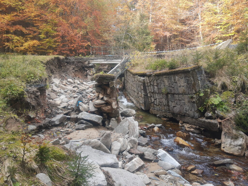
Straightened, deepened and canalized streams with paved channels accelerate the outflow of water from our territory and do not provide suitable living conditions for a large number of aquatic animals. At the same time, the self-cleaning ability of streams is limited.
Underground drainage systems and ditches built to drain wetlands and agricultural land accelerate water runoff and prevent it from seeping deeper. Runoff from fields contaminates waterways and waterbodies.
Accelerated runoff from our land is reducing the reserves of groundwater and surface water, with streams drying up more often. In summer, there is a shortage of water for cooling and the functioning of technical infrastructure, such as power plants and wastewater treatment plants.
Built-up floodplains prevent the natural overflow of rivers during high flows. Poorly designed structures cause flooding of entire city districts. This causes extensive damage to property and endangers the safety of residents.
High barriers prevent the migration of fish and other animals and prevent the natural flow regime – this causes increased erosion of the banks and further deepening of the stream.
Aquatic and wetland ecosystems are among the most endangered habitats, due to insensitive interventions in stream morphology, drainage, pollution and excess nutrients in the environment, and the spread of invasive species.


Agricultural land
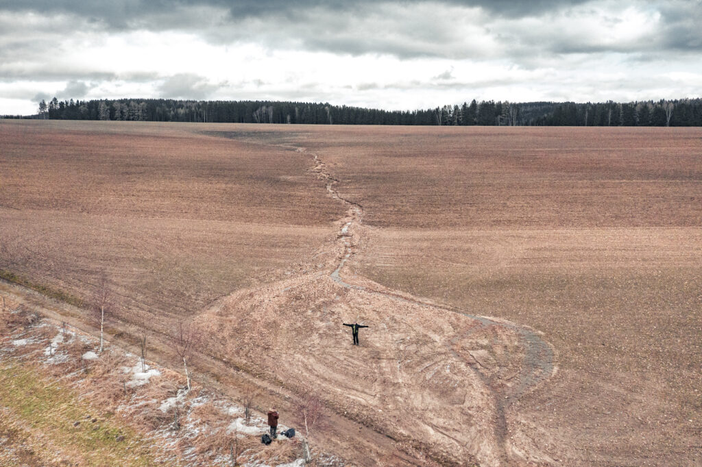
Large areas of bare soil are threatened by water and wind erosion. Dust from the fields pollutes the air. We lose tons of topsoil to mudflows every year, and the property of residents in adjacent municipalities is at risk.
By using heavy machinery to cultivate soil with a low organic content, the soil becomes compacted, capillary pores disappear, water does not soak into deeper layers and flows over the surface.
Soil is our largest reservoir of water, but without enough organic matter, it is unable to effectively retain and release water.
The low proportion of organic matter in the soil makes farmers dependent on the application of high doses of mineral fertilizers, which are then leached from the soil in high concentrations into waterways and areas.
Excessive use of chemicals in agriculture destroys soil life and accumulates in the food chain. Application of sprays under unsuitable weather conditions contaminates the environment.
Large fields of chemically treated single-species crops do not provide suitable shelter for field game species, which are now endangered and declining. The use of herbicides has resulted in the rarity of even previously common field weeds.
Even slightly sloping land is at risk of water erosion. Downhill grooves accelerate water runoff and cause erosion.
The water that is absorbed is quickly drained by drainage systems on more than 25% of agricultural land.
Due to collectivization, the land became unified, borders, roads and alleys disappeared. The landscape lost its variety, diversity and permeability. Czechia has the largest average farm size in the EU.
Temperature fluctuations and alternating water regimes with long periods of drought and sudden, intense and short rains cause crops to have low yields and are more susceptible to attack by pests and other diseases.

Forests
Drought and heat waves are contributing to more frequent forest fires. Fires pollute the air, endanger property and human lives.
Dense stands of trees compete for water. Lack of water affects the viability of the tree, stopping transpiration and wood formation, and the tree dies.
Same-aged, single-species and dense stands are more susceptible to diseases, disasters and pest attacks.
The bark beetle epidemic is a consequence of large, single-age spruce monocultures grown at low altitudes and nitrate stress. Due to global warming, bark beetles have up to three generations per year. When in high numbers, they also attack healthy trees.
Extensive clearings expose the remaining vegetation, which then suffers from uprooting and collapse. Deforested areas suffer from drought, unable to effectively capture and retain water.
Forest soils are naturally more porous than other soils, and the impact of rolling on soil compaction is noticeable even after decades. Compacted soil cannot effectively absorb water.
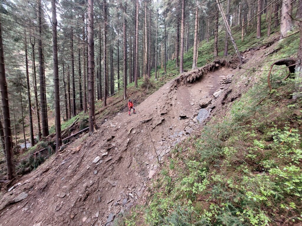
Approach lines, cableway cuts and gradients accelerate water runoff and create deep erosion grooves. Accelerated runoff also results in faster culmination of flood waves.
Overpopulated ungulates destroy new plantings and prevent natural forest regeneration. Protection measures for new crops and their regeneration are financially very expensive – in the order of billions every year.
Invasive insect species cause widespread mortality of stands. Invasive tree species displace our native species, thus eliminating entire communities of insects, fungi and animals dependent on them.


Climate change
Climate change is resulting in significant temperature fluctuations. Wind flows have much more energy, effectively drying out the landscape and soil.
The small water cycle is disrupted by insufficient greenery in the landscape and dried soil.
Evaporation has increased by up to 50% over the past 20 years due to climate change. It contributes to the salinization of some types of soil and causes wetlands and water bodies to dry out.
Extreme weather fluctuations cause longer periods of drought. Precipitation falling on parched soil does not soak in, but flows over the surface and in straightened channels away from our territory.
On average, the same amount of precipitation falls on our territory, but its distribution over the year has changed. Rainfall falls in a shorter period with greater intensity.
A lack of snow during the winter results in a lack of water during the growing season. Groundwater is not replenished.
Accelerating rainfall runoff results in a faster culmination of destructive flood waves.
Rising temperatures accelerate the development of insect pests. Long-term tropical temperatures have an impact on the physiology of cultivated plants and ourselves. During the summer, fields and large permanent grasslands and built-up areas become heat islands that repel precipitation.
Climate change is causing a shift in vegetation belts. The upper forest boundary is shifting, putting our most precious ecosystems in mountain areas at risk.
The Living Landscape model is designed as a multifunctional methodological approach to solving the fundamental problems of any landscape with the aim of reducing all types of drought, soil erosion, increasing carbon storage, biodiversity and landscape cooling, reducing flooding and restoring the hydrological system in the landscape.
Feasibility study of the Living Landscape Model
The feasibility study is made for the entire area of the 4th order river basin, with an approximate area of 10 km2 and more. The area of this area is large enough for the proposed measures to have a real positive impact on the water cycle in the entire basin, to minimize erosion in all areas at risk of erosion, and to support the flow of water.
We propose a large number of small measures that build on each other and support each other. We try to limit existing economic entities as little as possible and support their transition to sustainable management. The proposed measures are economically beneficial while maximally supporting the ecological functions of the landscape. The landscape becomes permeable, resilient and alive.
Analysis and study of background materials
We will prepare all necessary project documents and a graphic project for the given area according to our methodology.
Current orthophoto and basic maps, historical maps, scientific maps and all technical infrastructure. Historical maps that show the state of the land before modern infrastructure.
We study relevant scientific literature and all geoscientific, hydrological and other relevant maps. We take into account all compulsory municipality development plans and protected areas and other specially protected or restricted zones etc.
Mapping the current state of the terrain with the help of the public
We use a mobile application and a drone in cooperation with hdrones to map the area.
Using the GPS on your mobile phone, we record all points of interest along with photographic documentation with an accuracy of up to two meters. The collected data is sent via the cloud directly to the prepared graphic project.
The recorded points – erosion grooves, drainage pipes, water features and others – are the basis for the subsequent design of nature-based measures in the graphic project.
The application is freely available for smartphones and is easy to use, so we can involve everyone in trivial mapping.
Graphical design of nature-friendly measures in QGIS
Based on the analysis of the data and field mapping, we propose nature-based measures according to valid and recommended agricultural and nature conservation methodologies in the freely available QGIS program.
All proposed measures and mapped points have their own label based on our clear map key.
Each designed element has its own list of attributes, where dimensions and all necessary parameters and properties are entered. This facilitates the creation of project documentation and all supporting documents necessary for the implementation of the project.
Feasibility study text document
The project is briefly summarized in a text document with the results of the analysis and the significance of the proposed measures in the graphic design project. The document is divided into three main parts:
The general part of the text document will present the natural conditions of the given area and the historical context of the landscape.
In the analytical part, we describe the process and results of mapping and studying all archival, scientific and map data. We identify critical points in the cadastre that need to be addressed first.
In the design part, we focus on specific nature-friendly measures proposed in the QGIS graphic project in a given location.
Interactive graphic project in QGIS
All necessary layers for analysis and design of measures, together with mapped points of interest, are contained in one project, which is stored on the server – so multiple people can work on the project at the same time. We use the open source software QGIS and plug-ins, which are free to download. According to the needs of the project we create some plug-ins ourselves .
Based on the client’s needs, we create a web viewer where a web browser and an internet connection are sufficient to view the entire project. This allows the general public to become familiar with the proposed measures in the area via a link.
Landscape adaptation and water retention
Watercourses and areas
We are returning water features and wetlands to the landscape. We propose new ponds, lakes or pools in suitable locations. Returning water to the surface and supporting retention and infiltration throughout the landscape contributes to cooling the landscape and restoring the small water cycle.
Revitalization of watercourses consists mainly of returning them to their original natural channels according to local geomorphology. The course of the streams is lengthened and the water flow is slowed down. Indented and roughened channels provide a safe haven and a place for the reproduction of many species of animals and plants. The natural channel allows water to infiltrate the surrounding soil, making the flows more stable.
Loosening the flow in the floodplain supports natural fluctuations in the level during the year, a wider spillway means further slowing down the flow even in the event of floods. Polders and controlled spillways are other measures that we propose to increase the safety of residents and their property.
Large water reservoirs are not only a source of drinking water, but also an important source of cooling water and irrigation. The quantity of water in them is influenced by factors throughout the basin. By slowing down the outflow of water in the upper parts of the streams at the same time as supporting infiltration throughout the basin, we will prevent excessive drying of the reservoirs in the summer months. By supporting sustainable management and appropriate measures on agricultural land, we will prevent runoff from fields and water pollution and their eutrophication.
Agricultural land
Soil takes thousands of years to form and can be lost in a single rainstorm – surface runoff from fields must be prevented. On agricultural land, we strive for functional contouring to limit water and wind erosion using plantings, ridges and infiltration strips. On flat land with a slope of up to 2%, we primarily address windbreaks and the proportion of greenery. On land with a slope of over 2%, we primarily address water erosion, and only then wind erosion.
We use drainage systems that were built to drain large areas of agricultural land and wetlands. We interrupt the found drainage pipes, especially in valleys, with the aim of creating a series of interconnected terrain depressions with dams. These structures function as mini-polders or pools based on the water content of the pipes. The small dimensions of the structures do not disrupt the landscape character – they are almost invisible in the landscape, they hardly take up any usable area and they are very effective. The construction is cheap, because all the material remains in place. The cascades created in this way effectively slow down the water runoff, the water returns to the surface and to the nearby surroundings. Together with the grassing of the valley, erosion drops to zero.
We support and help farmers switch to agroforestry and regenerative farming, which is key to restoring degraded and intensively farmed soils.
Increasing the proportion of organic matter in the soil will increase water retention and infiltration, as well as crop yields. Soil is an important reservoir of water not only for plants, but also for surface water and groundwater.
Reasonable grazing stimulates the root system of meadow vegetation, reduces erosion and supports biodiversity. Local production and limiting feed imports prevent meadow degradation due to their abandonment.
Forests
In forests, we apply contouring in several ways. Using so-called restorative reinforcing ribs, when small cuts (no larger than the height of the forest stand) are created on the forest plot in the shape of an overlapping checkerboard. Such small cuts do not expose the growing stand to the effects of wind. This contouring is most suitable on sloping land and sloping forest clearings, when the felled trunks are left in place perpendicular to the slope. Trunks placed in this way create a terrain wave that slows down the flow of water, prevents erosion and accumulates litter, dead wood slowly decomposes and helps retain water – thus creating a suitable environment for the natural renewal of the forest and soil.
We solve the problem of erosion prevention on unpaved forest roads by using a series of mobile terrain waves depending on the slope of the road. This measure slows down the flow of water and prevents the formation of deep erosion grooves on the roads, the water is led into infiltration pits. This supports the infiltration of water in the forest.
We solve downhill movements using the know-how of AQUA TERRA INOVA s.r.o. The pit-dam-pit system helps water to soak in where it falls and not flow away over the surface.
Forest soils act like a sponge, due to their high porosity – unless compacted by heavy machinery. Mixed plantings, appropriate tree species composition and careful management, a variety of stands and plenty of dead wood and undergrowth can restore the water-retaining function of soils and thus improve the hydrological regime in the entire basin.
The most effective solution to problems in our landscape is the implementation of a large number of interconnected small, nature-based measures across the entire landscape.
Landscape plan for adaptation of the Czech Republic to climate change
The landscape and its processes need to be approached as a whole if we want a prosperous and culturally valuable landscape, resilient, vibrant and safe. By restoring greenery and water to at least 10% of the agricultural landscape, we will help adapt the landscape to the inevitable ongoing climate change and its impacts.
Our goal is to create a unified Landscape Plan for Adaptation to Climate Change by gradually processing the entire territory of the Czech Republic according to the Living Landscape Model – to increase the resilience of the landscape to the impacts of extreme weather fluctuations, droughts and floods, and to restore its natural processes with regard to the safety and needs of citizens, owners, local governments and the state.
Citizen science
We organize lectures for municipalities and those interested in a feasibility study, where we present the Living Landscape Model and its main benefits. Before the start of the study, the plan is presented to the public in the area. We organize commented walks for citizens directly in the area being studied.
We reach out to local residents and look for people interested in becoming mappers. Ideally, a group of local citizens will be formed who, with our help and under expert supervision, will work on a feasibility study according to the Living Landscape Model methodology.
The Living Landscape model includes an above-standard level of public participation, thereby contributing to citizens’ interest in the state of the landscape in which they live and its adaptation to climate change.
Living landscapes
Separate subjects with the licence to use the Living Landscape Model (Model Živá krajina) tools and methodology.
Živá krajina Podbeskydí
e-mail: ziva.krajina.podbeskydi@seznam.cz
tel.: +420 777 199 045
Živá krajina Vysočina
e-mail: zivakrajina.vysocina@gmail.com
tel.: +420 725 089 460
Živá krajina Želivka a okolí
e-mail: jan.cihlar@zivakrajina.info
tel.: +420 606 752 220
Živá krajina Českého severu
tel.: +420 603 529 825
Model Živá krajina a Živá krajina – texts and logos are protected by industrial trademarks 398854, 398855, 401222 and 401228. The assembly of the Living Landscape Model (Model Živá krajina) is protected by copyright law.